Map of Canada (1886-89)
Map of the provinces and territories of Canada as they were between 1886 and 1889. In 1886, the District of
Map of the Denver Rio-Grande Railroad (1904)
Here is a detailed map of the Denver rio-Grande Railroad in 1904. This chart may prove useful to both TPO
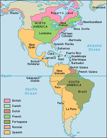
Map of Spanish Colonies in the Americas
The Spanish colonies in America started falling during the Peninsular War when Spain itself was under attack from Napoleonic troops.
Map of Newfoundland, Nova Scotia, New Brunswick & West Indies (1844)
This antique map shows Newfoundland, Nova Scotia, New Brunswick and the West indies in 1844. Postal historians may find this
United States Maps: North Carolina (1925)
Here is a superb map for postal historians and collectors of of North Carolina postmarks/cancels. It shows that state in
Railway Service Map of Michigan 1898
Fro Travelling Post Office collectors and rail buffs, an historic railway map of Michigan in 1898.


